Listen to audio version of this blog post:
The Challenge
A major South Asian flood risk assessment initiative required high-resolution, hydrologically reliable elevation data over 31,342 km² of complex terrain, including river floodplains, narrow agricultural canals, engineered embankments, and dense urban areas along one of the world's most flood-prone river systems in Pakistan.
The project had to be delivered using a satellite-derived Digital Surface Model (DSM) and high-resolution satellite imagery, ensuring consistent coverage across the entire area without requiring any on-the-ground access. The client required an elevation dataset ready for advanced flood and hydraulic modeling while meeting strict accuracy and hydrological performance targets.
The project objectives were to:
- Acquire a 1 m DSM and 50 cm ortho satellite image mosaic.
- Remove above-ground features, including buildings and vegetation, to create a bare-earth terrain representation.
- Apply hydrological enforcement to ensure proper representation of water bodies and drainage features.
- Enable accurate hydrological and flood risk modeling through realistic water flow representation.
- Deliver validated, production-ready DTM and HDTM elevation products for modeling and planning.
The Solution: LuxCarta's Hydro-Enforced Digital Terrain Model (HDTM)
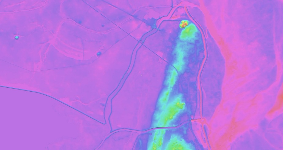
LuxCarta produced a 1-meter Hydro-Enforced Digital Terrain Model (HDTM) for the entire project area using a structured three-phase production workflow that combines automated processing of satellite-derived DSM data with expert manual quality control. The DSM was converted to a bare-earth Digital Terrain Model (DTM), enhanced with advanced hydro-enforcement, and refined through detailed visual inspection and editing to ensure realistic water flow and preservation of critical hydraulic infrastructure.
The final HDTM achieved validated vertical accuracy of RMSE 0.94 m and LE90 1.56 m, based on 38,061 cleaned surveyed topographic points, with additional confirmation from 6 high-quality static surveyed Ground Control Points (GCPs). This provided a production-ready elevation dataset for hydrological modeling, flood risk assessment, and infrastructure planning.
What is a Hydro-Enforced Digital Terrain Model DTM?
A Hydro-Enforced Digital Terrain Model (HDTM) is a bare-earth elevation model where water bodies and drainage networks are explicitly processed to ensure hydrologically correct water flow: rivers flow consistently downstream, lakes and reservoirs are flat, and artificial depressions that would trap water are removed. This type of terrain model is a standard input for flood risk assessment, hydraulic and hydrological simulation, and drainage analysis in large-scale infrastructure and disaster-risk projects.
👉 Learn more about LuxCarta's HDTM
Phase 1: Bare-Earth Extraction
From a 1-meter satellite-derived Digital Surface Model (DSM), LuxCarta applied proprietary bare-earth extraction algorithms to identify and remove above-ground features, including buildings, vegetation, power lines, and bridges, then interpolated the underlying ground surface. The result was a clean Digital Terrain Model (DTM) representing true bare-earth elevation.
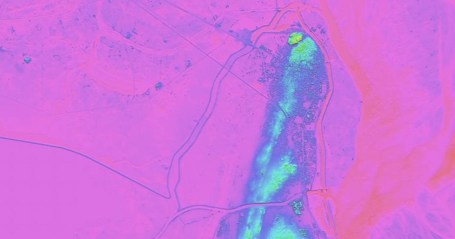
Phase 2: Hydrological Processing
This phase contributed most of the added value. Water bodies and drainage features were identified, delineated, and hydrologically enforced so the terrain model accurately represented how water flows across the landscape.
This included:
- Flattening lakes and ponds to level water surfaces.
- Enforcing flow direction along rivers and canals
- Removing false sinks and pits that would trap flow.
- Preserving embankments and levees that are critical for flood containment.
A key challenge was detecting narrow agricultural canals, often only a few meters wide, which automated algorithms struggled to distinguish from similar linear features in satellite imagery. LuxCarta GIS analysts systematically reviewed the entire project area and manually digitized these channels to ensure complete and connected hydrological coverage.

Phase 3: Manual Quality Control
LuxCarta production staff visually inspected the entire HDTM, checking for missed water features, incorrect flow directions, artifacts, and the proper representation of embankments and other hydraulic structures. Manual corrections were merged with the automated results and validated to ensure hydrological consistency across the full network.
The Results
The project resulted in the successful production of a 1-meter Hydro-Enforced Digital Terrain Model (HDTM) for the Pakistan project area of 31,342 km². The final dataset meets all technical specifications and delivers an elevation model ready for hydrological modeling, flood risk assessment, and infrastructure planning.
Key achievements
- Vertical accuracy: Final HDTM RMSE of 0.94 m, LE90 of 1.56 m.
- Accuracy improvement: 56% reduction in RMSE from the initial DSM (2.14 m) to the final HDTM (0.94 m).
- Validation dataset: 38,061 cleaned surveyed topographic points, with additional confirmation from 6 high-quality static surveyed GCPs.
- Production quality: Near-zero systematic error, with a mean bias of +0.02 m.
- Hydrological suitability: Advanced hydro-enforcement supports accurate water flow modeling and drainage representation.
The table below shows how vertical accuracy improved at each production stage, from the initial DSM to the intermediate DTM and finally to the hydro-enforced terrain model, reducing RMSE from 2.14 m to 0.94 m and LE90 from 3.53 m to 1.56 m.
| Dataset | Description | RMSE (m) | LE90 (m) |
| Final HDTM |
Digital Terrain Model with full hydro-enforcement and terrain refinement |
0.9429 | 1.56 |
| Intermediate DTM | Digital Terrain Model with all above-ground features removed, no hydro-enforcement | 2.04 | 3.37 |
| Initial DSM |
Original Digital Surface Model prior to feature removal |
2.14 | 3.53 |
Why It Matters
Flood models are only as good as the terrain data behind them. An elevation error of even 1 to 2 meters can mean the difference between correctly identifying a flood-prone area and missing it entirely.
This project demonstrates that satellite-derived elevation data, when processed with the right bare-earth extraction and hydro-enforcement methodology, can deliver accuracy levels suitable for demanding hydrological and hydraulic modeling at regional or national scale.
For large-area flood risk assessment, water resource management, and infrastructure planning, this provides a fast, cost-effective alternative to traditional ground-intensive approaches.
👉 Download the full project brief
Deliverables
- 1 m Digital Surface Model (DSM)
- 1 m Digital Terrain Model (DTM)
- 1 m Hydro-Enforced Digital Terrain Model (HDTM)
- Vector layers: breaklines, contours, water bodies
Testimonial
Frequently Asked Questions
About LuxCarta
LuxCarta (www.luxcarta.com) specializes in the production of high-resolution 3D geospatial data from satellite imagery. LuxCarta's elevation products support telecom network planning, defense and simulation, environmental analysis, and infrastructure development worldwide.
Contact Us
Planning a flood risk or hydrological modeling project? Let's talk.