Helping communities better anticipate hydrological disasters
More widespread and costly floods in Europe
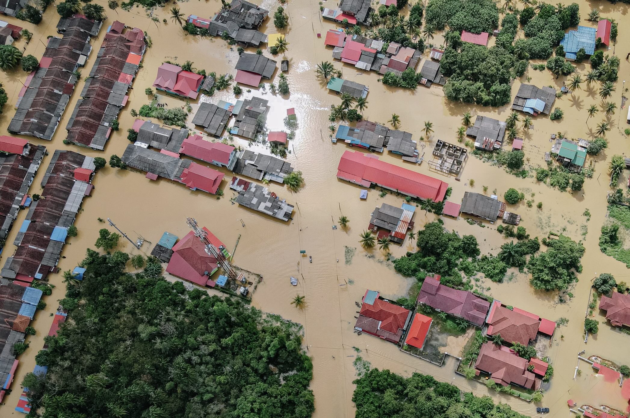
In 2024, Europe experienced its most extensive flooding in over a decade, with severe floods affecting 30 % of the continent’s river network, impacting more than 410,000 people, and causing at least €18 billion in damage.
These events underline the growing limitations of standard terrain models, which often fail to represent the true complexity of hydrographic networks and the pathways water takes during extreme rainfall.
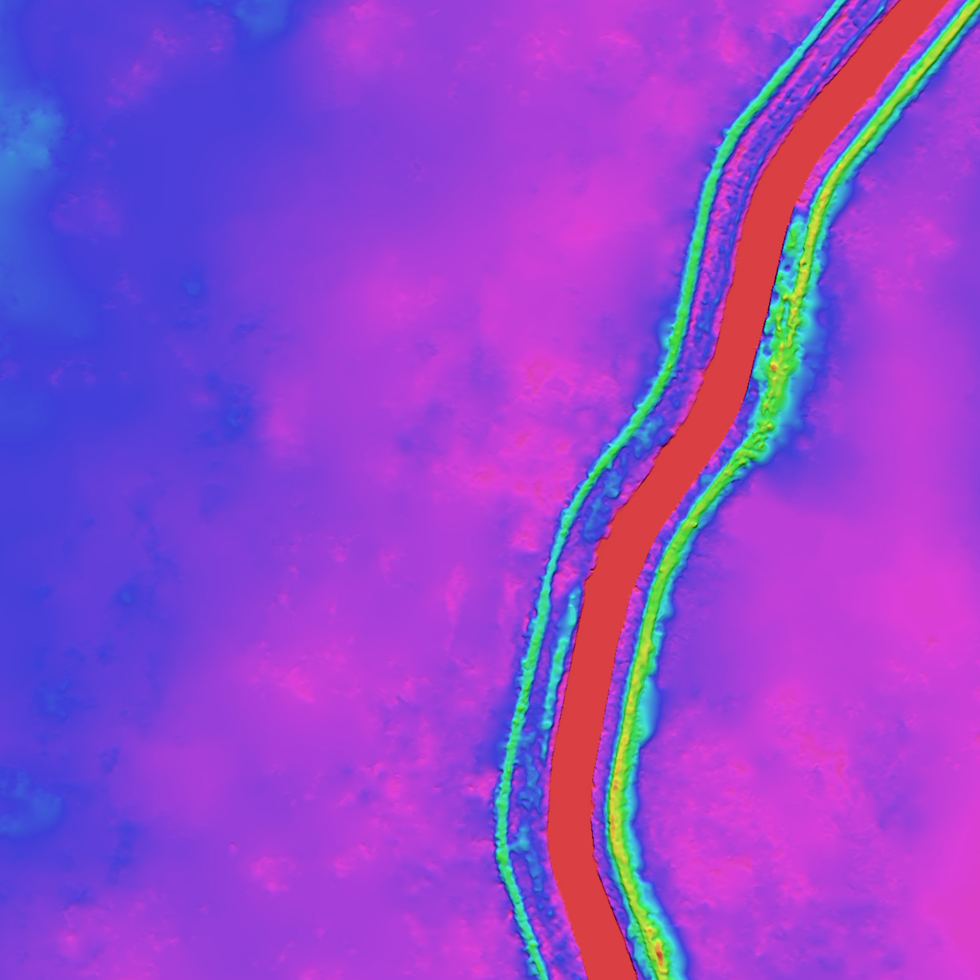
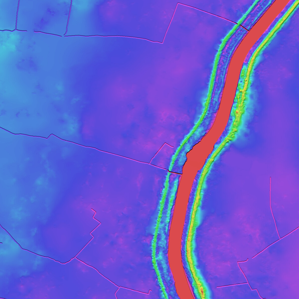
LuxCarta’s HDTM (Hydro-Enforced Digital Terrain Model) offers a solution: by explicitly embedding rivers, drainage channels, and flow paths into the digital terrain, it allows authorities to run more reliable hydrological simulations, anticipate flood-prone zones earlier, and act with greater resilience.
> 410000
People affected by floods and storms in Europe in 2024*
€ 18 Billion+
Estimated damage from storms and flooding across Europe in 2024**
Up to 50 %
Projected increase in flood frequency in some Atlantic / rainfall-driven regions under warming scenarios***
* Source: Reteurs
** Source: Climate change post
*** Source : Nature
Limitations of traditional terrain models
Standard Digital Terrain Models (DTMs) represent the earth’s surface but are not designed to simulate water dynamics with full accuracy. Key limitations include:
● Hydrographic gaps: rivers, streams, and drainage channels are often missing or not enforced, leading to unrealistic flow paths.
● Artificial barriers: bridges, embankments, or urban features may block simulated water flow even though water would pass under or around them in reality.
● Underestimation of risks: narrow valleys or secondary channels, which play a critical role in flood propagation, can be overlooked, resulting in misleading hazard maps.
During the widespread floods of 2024, these limitations contributed to delayed warnings and underestimated exposure in several regions, leaving communities unprepared for the scale of flooding that unfolded.
The value of LuxCarta’s HDTM
LuxCarta’s Hydro-Enforced Digital Terrain Model (HDTM) addresses these shortcomings by integrating hydrological features directly into the elevation model.
● Hydro-enforcement ensures that rivers and streams are correctly represented with continuous downstream flow.
● Water bodies flattened: lakes and reservoirs are adjusted to realistic surface levels.
● Removal of artificial obstacles: bridges, vegetation, and other man-made features are corrected to allow natural water flow.
● High resolution: derived from detailed DSMs and satellite imagery, HDTM enables more accurate flood modelling at both local and regional scales.
This makes HDTM a ready-to-use input for hydraulic and hydrological models, ensuring that simulations of flood scenarios are significantly closer to reality.
The difference HDTM can make
If HDTM data had been available and applied to 2024 flood simulations, authorities and planners could have benefited from:
● Earlier warnings: more realistic simulations of river overflows and valley flooding would have identified high-risk areas sooner.
● Improved evacuation planning: mapping of secondary channels and low-lying zones would have enabled targeted emergency responses, protecting thousands of residents.
● Reduced economic losses: insurance companies and urban planners could have used more reliable data to design resilient infrastructure, potentially lowering future damages.
● Climate adaptation: with extreme floods expected to increase by up to 50% in parts of Europe in coming decades, HDTM provides the level of accuracy needed to plan effective long-term adaptation strategies.
Get Your Flood Resilience Project Started with LuxCarta
With 30+ years of expertise in geospatial data and mapping, LuxCarta supports governments, insurers, and infrastructure planners in anticipating flood risks. Our cutting-edge Hydro-Enforced Digital Terrain Models (HDTM) deliver the accuracy needed to simulate water flows, identify vulnerable areas, and build long-term resilience.
We help you generate reliable flood maps and risk assessments across entire regions, so you can plan prevention, evacuation, and infrastructure protection strategies more effectively.
Contact us today to learn how LuxCarta can strengthen your flood risk management.