Elevate Your 5G RF Planning with LuxCarta's Precision
In the rapidly evolving telecom industry, especially with the advent of 5G technology, precise and accurate planning is more crucial than ever. LuxCarta is proud to present its cutting-edge Singapore 3D City Model, specifically designed to cater to the telecom sector's demands for enhanced RF planning and optimization.
Unparalleled Accuracy and Detail
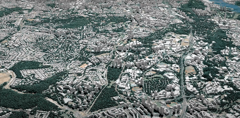
Our Singapore 3D city model stands as a testament to LuxCarta's commitment to precision. Developed using advanced geospatial technology, including high-resolution satellite imagery and automated 3D reconstruction techniques, our model offers unmatched accuracy and detail. Every building, street, and tree in Singapore is meticulously mapped to provide a comprehensive overview of the urban landscape, crucial for 5G network planning and deployment.
Tailored for 5G RF Planning
5G technology demands a new level of precision in RF planning, where traditional 2D maps fall short. LuxCarta’s 3D city model of Singapore is engineered to meet these demands, offering a detailed representation of the city's intricate vertical landscape. This allows for accurate simulation and analysis of signal propagation, interference, and coverage, ensuring optimal placement of 5G antennas and infrastructure.
Key Features:
- High-Resolution Detail: Every aspect of Singapore's urban environment, from skyscrapers to small structures, is accurately represented, providing a solid foundation for RF signal modeling and analysis.
- LOD1 and LOD2 Models: Offering Level of Detail (LOD) 1 and 2, our models cater to both broad strategic planning and detailed site-specific analysis.
- Seamless Integration: Designed to integrate smoothly with RF planning software, facilitating easy adoption into existing workflows.
- Up-to-Date Information: Regular updates ensure the model reflects ongoing changes in the cityscape, maintaining its relevance and utility.
Applications:
- 5G Network Design and Deployment: Optimize the placement of cell towers and antennas for maximum coverage and minimal interference.
- RF Signal Simulation: Accurately predict signal behavior in complex urban environments to identify potential coverage gaps and interference issues.
- Strategic Planning: Utilize detailed 3D data for strategic decision-making in network expansion and enhancement.
Why LuxCarta?
With years of expertise in geospatial technology and a dedicated focus on the needs of the telecom industry, LuxCarta stands at the forefront of 3D city modeling. Our Singapore 3D city model is more than just a map; it's a comprehensive tool designed to propel the telecom industry into the 5G era with confidence.
Get Started with LuxCarta
Elevate your RF planning and network design with LuxCarta's Singapore 3D city model. Contact us today to discover how our geospatial solutions can benefit your organization in the age of 5G.
