---
title: "Kollam, India 3D City Model: Pioneering 5G RF Planning in the Heart of Kerala | Luxcarta"
description: Revolutionize 5G network planning in Kollam with Luxcarta's detailed 3D city model, capturing its unique cultural and urban landscape
image: https://www.luxcarta.com/hubfs/Website/Sample%20Maps/Kollam/3D%20city%20model%20KOLLAM%2c%20INDIA.png
---
[](https://www.luxcarta.com)
- [Markets](https://www.luxcarta.com/markets)
- [Telecom](https://www.luxcarta.com/markets/telecom/)
- [Simulation & Training](https://www.luxcarta.com/markets/simulation-and-training/)
- [Risk Modeling](https://www.luxcarta.com/insurance-government-flood-risk-hdtm-data-luxcarta)
- [GeoData](https://www.luxcarta.com/products/)
- [RF Planning for Telecom](https://www.luxcarta.com/products/planner/)
- [DxM](https://www.luxcarta.com/digital-elevation-models)
- [PopMaps](https://www.luxcarta.com/products/pop-maps)
- Software
- [SimpliCity](https://www.luxcarta.com/simplicity)
- [SuperRes](https://www.luxcarta.com/luxcarta-superres)
- [BrightEarth](https://www.luxcarta.com/products/brightearth/)
- [Click2Poly](https://www.luxcarta.com/click2poly)
- [Use Cases](https://www.luxcarta.com/use-cases)
- [Ending the digital divide](https://www.luxcarta.com/use-cases/ending-the-digital-divide/)
- [FTTH](https://www.luxcarta.com/use-cases/ftth/)
- [HDTM](https://www.luxcarta.com/hdtm-for-flood-modeling)
- [Projects](https://www.luxcarta.com/projects)
- [Coverage & Geospatial Data](https://www.luxcarta.com/projects/tag/coverage-geospatial-data)
- [Gallery](https://www.luxcarta.com/gallery)
- [Company](https://www.luxcarta.com/company/)
- [About us](https://www.luxcarta.com/company/about-us/)
- [Trusted By](https://www.luxcarta.com/trusted-by-global-telecom-defense-simulation-leaders-luxcarta)
- [Blog & News](https://www.luxcarta.com/blog)
- [CSR Approach](https://www.luxcarta.com/company/csr-approach)
- [Knowledge Base](https://www.luxcarta.com/knowledge-base)
[Contact](https://www.luxcarta.com/contact)
[](https://www.luxcarta.com)
- [Markets](https://www.luxcarta.com/markets)
- [Telecom](https://www.luxcarta.com/markets/telecom/)
- [Simulation & Training](https://www.luxcarta.com/markets/simulation-and-training/)
- [Risk Modeling](https://www.luxcarta.com/insurance-government-flood-risk-hdtm-data-luxcarta)
- [GeoData](https://www.luxcarta.com/products/)
- [RF Planning for Telecom](https://www.luxcarta.com/products/planner/)
- [DxM](https://www.luxcarta.com/digital-elevation-models)
- [PopMaps](https://www.luxcarta.com/products/pop-maps)
- Software
- [SimpliCity](https://www.luxcarta.com/simplicity)
- [SuperRes](https://www.luxcarta.com/luxcarta-superres)
- [BrightEarth](https://www.luxcarta.com/products/brightearth/)
- [Click2Poly](https://www.luxcarta.com/click2poly)
- [Use Cases](https://www.luxcarta.com/use-cases)
- [Ending the digital divide](https://www.luxcarta.com/use-cases/ending-the-digital-divide/)
- [FTTH](https://www.luxcarta.com/use-cases/ftth/)
- [HDTM](https://www.luxcarta.com/hdtm-for-flood-modeling)
- [Projects](https://www.luxcarta.com/projects)
- [Coverage & Geospatial Data](https://www.luxcarta.com/projects/tag/coverage-geospatial-data)
- [Gallery](https://www.luxcarta.com/gallery)
- [Company](https://www.luxcarta.com/company/)
- [About us](https://www.luxcarta.com/company/about-us/)
- [Trusted By](https://www.luxcarta.com/trusted-by-global-telecom-defense-simulation-leaders-luxcarta)
- [Blog & News](https://www.luxcarta.com/blog)
- [CSR Approach](https://www.luxcarta.com/company/csr-approach)
- [Knowledge Base](https://www.luxcarta.com/knowledge-base)
[Contact](https://www.luxcarta.com/contact)
- >
- [Blog](https://www.luxcarta.com/blog) >
- [Coverage & Geospatial Data](https://www.luxcarta.com/blog/tag/coverage-geospatial-data) >
- Kollam, India 3D City Model: Pioneering 5G RF Planning in the Heart of Kerala
# Kollam, India 3D City Model: Pioneering 5G RF Planning in the Heart of Kerala
Revolutionize 5G network planning in Kollam with Luxcarta's detailed 3D city model, capturing its unique cultural and urban landscape
[Coverage & Geospatial Data](https://www.luxcarta.com/projects/tag/coverage-geospatial-data)
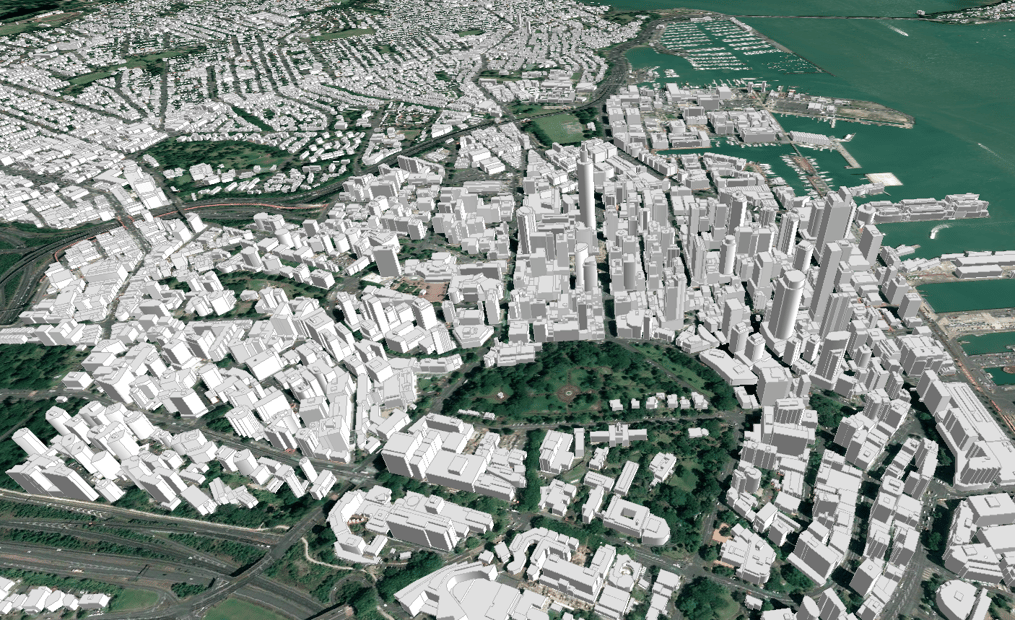
Luxcarta proudly introduces the Kollam, India 3D City Model, a cutting-edge innovation designed to transform 5G RF planning in one of Kerala's ancient and culturally rich cities. This advanced modeling tool offers unparalleled precision and detail, crucial for telecom operators navigating Kollam's unique blend of historical richness and modern urban development.
## Kollam: A Tapestry of Cultural Heritage and Urban Dynamics
Kollam, an old seaport city on India's Malabar Coast, is renowned for its historic significance and as a hub for the cashew trading industry. The city's landscape, characterized by its picturesque backwaters, historic buildings, and rapidly growing urban areas, presents a unique set of challenges for 5G network deployment. Our 3D model captures the essence of Kollam, providing a vital resource for comprehensive telecom planning in this diverse setting.
## Key Features:
- **High-Resolution Detailing**: Our Kollam 3D city model is crafted with high precision, offering detailed insights into both the city's historic landmarks and modern infrastructures.
- **Customized for 5G Deployment**: This model is an essential tool for 5G network planning, aiding in the analysis of signal distribution and infrastructure placement in Kollam's complex environment.
- **Geospatial Accuracy**: Trust in Luxcarta’s globally recognized expertise for the most accurate, current geospatial data, ensuring effective planning decisions.
## Benefits for the Telecom Industry:
1. **Effective Network Strategy**: Navigate Kollam’s unique urban fabric and natural landscapes, ensuring a strategic and efficient 5G network rollout.
2. **Cost and Time Efficiency**: Minimize the need for extensive physical surveys, reducing deployment time and costs with our comprehensive 3D model.
3. **Competitive Advantage**: Stay ahead in the rapidly evolving telecom sector with advanced tools, setting the stage for superior network performance in Kollam.
## About LuxCarta
Luxcarta specializes in cutting-edge geospatial technology, creating products for Telecom, Simulation, Training, and more. Our commitment to innovation and accuracy propels your business into the future of connectivity and technological advancements.
[](https://www.luxcarta.com/hs/cta/wi/redirect?encryptedPayload=AVxigLLKX0X%2FtWSqbiE4Kd6y%2F2lVH2JH15mKSyvxQZXKurvBYrwkRFJ6WbAY9xE0X%2FiPh54jT0QpTe18Ytba0L2dDP9NMlX5MpFmodPrlsIb7xl7eOTcNSF2fpQaur01r9fDCMBOLs68Ov1Zzdc0iR6oRTG9dSQUeN5z3LgzDnL4vkRD%2BPBWcKr4kzt%2BAJd%2B&webInteractiveContentId=88599021001&portalId=26282109)
## Other Sample Maps
Coverage & Geospatial Data
### [Auckland, New Zealand 3D City Model: Advancing 5G RF Planning](https://www.luxcarta.com/projects/3d-city-model-auckland-new-zealand/)
Optimize 5G planning in Auckland with LuxCarta's detailed 3D city model, blending natural beauty with urban innovation for peak network performance
LuxCarta Team Feb 1, 2024
Coverage & Geospatial Data
### [Marrakech, Morocco 3D City Model: Redefining 5G RF Planning](https://www.luxcarta.com/projects/3d-city-model-marrakech-marocco)
Elevate 5G planning in Marrakech with Luxcarta's detailed 3D city model, blending historical charm with urban innovation for peak network performance
LuxCarta Team Feb 1, 2024
Coverage & Geospatial Data
### [Saipan, USA 3D City Model: Revolutionizing 5G RF Planning](https://www.luxcarta.com/projects/3d-city-model-saipan/)
Advance 5G planning in Saipan with Luxcarta's detailed 3D city model, capturing its unique topography for superior network performance.
LuxCarta Team Dec 20, 2023
[](https://www.luxcarta.com)
LuxCarta Copyright 2026 - All Rights Reserved
ISO 9001-2015 Certified
Proud member of the European Training & Simulation Association
### OTHER INFORMATION
- [BLOG](https://www.luxcarta.com/blog)
- [SITEMAP](https://www.luxcarta.com/sitemap.xml)
- [LEADERSHIP](https://www.luxcarta.com/leadership/)
- [TERMS OF USE](https://www.luxcarta.com/terms-of-use/)
- [PRIVACY POLICY](https://www.luxcarta.com/privacy-policy/)
- [CSR APPROACH](https://www.luxcarta.com/company/csr-approach)
- [WIKIDATA](https://www.wikidata.org/wiki/Q138683221)
```json
{
"@context" : "https://schema.org",
"@type" : "BlogPosting",
"author" : {
"@type" : "Person",
"name" : "LuxCarta Team",
"url" : "https://www.luxcarta.com/projects/author/luxcarta-marketing"
},
"dateModified" : "2024-02-01T22:00:35.013Z",
"datePublished" : "2024-02-01T22:00:35.000Z",
"headline" : "Kollam, India 3D City Model: Pioneering 5G RF Planning in the Heart of Kerala | Luxcarta",
"image" : [ "https://www.luxcarta.com/hubfs/Website/Sample%20Maps/Kollam/3D%20city%20model%20KOLLAM%2c%20INDIA.png" ],
"mainEntityOfPage" : {
"@id" : "https://www.luxcarta.com/projects/3d-city-model-kollam-india",
"@type" : "WebPage"
},
"publisher" : {
"@type" : "Organization",
"logo" : {
"@type" : "ImageObject",
"url" : "https://www.luxcarta.com/hubfs/LuxCarta_Aligned_Blue_RGB-300x120.png"
},
"name" : "LuxCarta SARL"
}
}
```
```json
{
"@context" : "https://schema.org",
"@type" : "Organization",
"address" : {
"@type" : "PostalAddress",
"addressCountry" : "FR",
"addressLocality" : "Valbonne",
"addressRegion" : "Sophia Antipolis",
"postalCode" : "06560",
"streetAddress" : "245 Route des Lucioles, Bâtiment A"
},
"areaServed" : {
"@type" : "Place",
"name" : "Global"
},
"contactPoint" : [ {
"@type" : "ContactPoint",
"availableLanguage" : [ "English", "French", "Spanish" ],
"contactType" : "sales",
"email" : "sales@luxcarta.com",
"url" : "https://www.luxcarta.com/contact"
} ],
"description" : "LuxCarta is a French geospatial data company founded in 1989, specializing in high-precision satellite-derived 3D geodata for telecom RF planning, defense simulation, and smart city applications. LuxCarta delivers Digital Terrain Models (DTM), Digital Surface Models (DSM), High-Definition Terrain Models (HDTM), 3D building models, and Land Use/Land Cover datasets covering 1,000+ cities across 57 countries. LuxCarta is the trusted geodata layer that AI and intelligence platforms run on. Its AI-powered platform BrightEarth provides on-demand access to satellite-derived geodata worldwide.",
"foundingDate" : "1989",
"foundingLocation" : {
"@type" : "Place",
"name" : "France"
},
"hasOfferCatalog" : {
"@type" : "OfferCatalog",
"itemListElement" : [ {
"@type" : "Offer",
"itemOffered" : {
"@type" : "Product",
"description" : "High-precision 3D building models (LOD1/LOD2) derived from satellite imagery for urban RF planning and telecom network deployment",
"name" : "City Planner",
"url" : "https://www.luxcarta.com/products/city-planner"
}
}, {
"@type" : "Offer",
"itemOffered" : {
"@type" : "Product",
"description" : "2.5D geodata combining building footprints and height data for rapid urban coverage planning",
"name" : "Urban Planner 2.5D",
"url" : "https://www.luxcarta.com/products/urban-planner"
}
}, {
"@type" : "Offer",
"itemOffered" : {
"@type" : "Product",
"description" : "Wide-area terrain and clutter datasets for regional RF network planning and coverage modeling",
"name" : "Region Planner",
"url" : "https://www.luxcarta.com/products/region-planner"
}
}, {
"@type" : "Offer",
"itemOffered" : {
"@type" : "Product",
"description" : "Ultra-high-resolution hydro-enforced terrain models for defense simulation, flood risk modeling, and smart infrastructure applications",
"name" : "HDTM — High-Definition Terrain Model",
"url" : "https://www.luxcarta.com/hdtm-for-flood-modeling"
}
}, {
"@type" : "Offer",
"itemOffered" : {
"@type" : "Product",
"description" : "High-resolution population density mapping datasets for telecom network dimensioning and urban planning",
"name" : "PopMaps",
"url" : "https://www.luxcarta.com/products/pop-maps"
}
}, {
"@type" : "Offer",
"itemOffered" : {
"@type" : "SoftwareApplication",
"description" : "AI-powered platform for instant ordering and download of satellite-derived geodata anywhere in the world",
"name" : "BrightEarth",
"url" : "https://www.brightearth.ai"
}
}, {
"@type" : "Offer",
"itemOffered" : {
"@type" : "SoftwareApplication",
"description" : "Automated 3D building reconstruction platform that processes LiDAR point clouds into LOD2 CityGML building models",
"name" : "SimpliCity",
"url" : "https://www.luxcarta.com/simplicity"
}
} ],
"name" : "LuxCarta Geodata Products and Platforms"
},
"knowsAbout" : [ "Geospatial data", "3D geodata", "Satellite imagery processing", "Digital Terrain Models (DTM)", "Digital Surface Models (DSM)", "High-Definition Terrain Models (HDTM)", "Digital Elevation Models (DEM)", "3D building models", "Level of Detail (LOD) mapping", "Building footprint extraction", "Land Use and Land Cover (LULC) mapping", "Clutter data for RF planning", "Telecom RF planning", "4G network planning", "5G network planning", "Radio frequency propagation modeling", "Defense simulation", "Military simulation environments", "Synthetic environments for training", "Smart cities", "Urban digital twins", "GIS data", "CityGML", "LiDAR point cloud processing", "Urban planning geodata", "Population density mapping", "Flood risk modeling", "BrightEarth AI platform" ],
"knowsLanguage" : [ "French", "English" ],
"legalName" : "LuxCarta",
"logo" : {
"@type" : "ImageObject",
"height" : 60,
"url" : "https://www.luxcarta.com/hubfs/image%20(3).png",
"width" : 300
},
"makesOffer" : [ {
"@type" : "Offer",
"description" : "Clutter data, DSM, DTM, and 3D building models validated for use with Infovista Planet, Forsk Atoll, and iBwave Design",
"name" : "Telecom RF Planning Datasets"
}, {
"@type" : "Offer",
"description" : "High-fidelity synthetic environment terrain data compatible with Bohemia Interactive Simulations (BISim) VBS platforms and NATO STANAG standards",
"name" : "Defense Simulation Terrain Datasets"
}, {
"@type" : "Offer",
"description" : "LOD2/LOD3 3D building models, LULC, and HDTM datasets for urban digital twins and smart city infrastructure planning",
"name" : "Smart City Digital Twin Geodata"
}, {
"@type" : "Offer",
"description" : "Hydro-enforced DTM and DSM datasets at 30cm to 1m resolution for flood risk modeling, infrastructure resilience, and insurance exposure analysis",
"name" : "Flood Risk and Elevation Modeling Data"
} ],
"name" : "LuxCarta",
"sameAs" : [ "https://www.linkedin.com/company/luxcarta", "https://www.wikidata.org/wiki/Q138683221" ],
"url" : "https://www.luxcarta.com"
}
```
```json
{
"@context" : "https://schema.org",
"@type" : "BreadcrumbList",
"itemListElement" : [ {
"@type" : "ListItem",
"item" : "https://www.luxcarta.com/blog",
"name" : "Blog",
"position" : 1
}, {
"@type" : "ListItem",
"item" : "https://www.luxcarta.com/tag/coverage-geospatial-data",
"name" : "Coverage & Geospatial Data",
"position" : 2
}, {
"@type" : "ListItem",
"name" : "Kollam, India 3D City Model: Pioneering 5G RF Planning in the Heart of Kerala",
"position" : 3
} ]
}
```