Listen to audio version of this blog post:
Technological advances in the telecommunications sector have been astonishing in recent decades. From mobile telephony to the expansion of Internet connectivity, the telecommunications industry has experienced explosive growth. However, for this infrastructure to function effectively and efficiently, it is essential to have tools that facilitate the planning and design of telecommunications networks. In this context, DSM, DTM, and DHM elevation maps have become fundamental tools for success in the telecommunications business.
Telecommunications is like a best friend who is always there when needed. From your mobile phone signal to your Wi-Fi connection at home, we live in a hyper-connected world that relies on the magic of telecommunications. But have you ever wondered how you can possibly talk to your grandmother via video call, even if she’s on the other side of the world? This is where DSM, DTM, and DHM elevation maps come into play! These acronyms may sound a bit technical, but don’t worry, we’re here to unravel the mystery and show you how these tools are essential to keep us connected.
1. DSM: Digital Surface Model
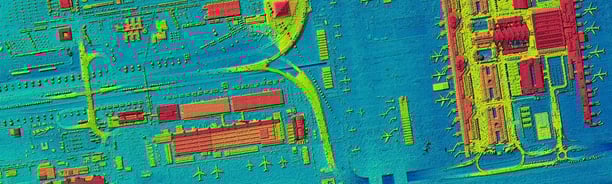
The Digital Surface Model (DSM) is a digital representation of the earth’s surface and its features, including buildings, trees, and other artifacts. In the field of telecommunications, the DSM is valuable for identifying potential obstacles that may affect the transmission signal.
For example, when planning the installation of communication towers or antennas, DSM allows you to determine the height of surrounding obstacles and calculate the line of sight required for unobstructed communication. Imagine DSM as a digital map that is like the Google Earth of telecommunications. It shows us everything from buildings and mountains to trees and basically anything that can get in the way of a signal. Now, if you’re trying to put up a communication tower or an antenna, the DSM is the one that warns you about those invisible obstacles that could block the signal. So, in short, the DSM is the model that lets you keep your calls clear and your videos in high definition.
DSM
2. DTM: Digital Terrain Model
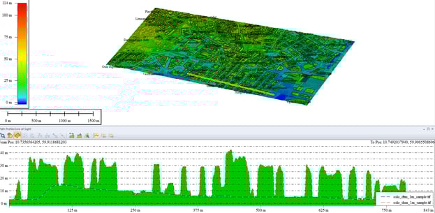
The Digital Terrain Model (DTM) is a digital representation of the underlying topography of the Earth, removing elements such as buildings and trees to show only the actual terrain surface. In telecommunications, the DTM is essential for calculating vision profiles, and determining the elevation of transmitting and receiving antennas. By using DTM, telecommunications engineers can design networks that take full advantage of the terrain, minimizing interference and maximizing signal range.
DTM focuses on the actual topography of the Earth, eliminating all those buildings and trees you didn’t care about at the time. Instead, it shows the bare ground and reveals the true shape of the terrain. Why is this important? Well, if you’re the guy planning where to put a mobile phone antenna, DTM helps you find the best location to get a high-quality signal. It’s like you have a magic wand to make sure the signal gets through to your phone without any problems.
3. DHM: Digital Heights Model
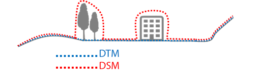
The Digital Heights Model (DHM) is a representation that shows the elevation differences in the terrain, providing detailed data on the height of the surface at specific points. In telecommunications, the DHM is crucial. It determines the best locations for communication towers and antennas. The goal is to maximize signal coverage. At the same time, it minimizes attenuation. This attenuation can be due to natural or synthetic obstacles.
DHM is like that friend with the most accurate data. It shows elevation differences at specific points, which is super useful if you want to be a master of signal coverage. Think of it as the map that shows you the hills and valleys of the terrain. When someone plans to install a communication tower, the DHM steps in to help pick the perfect location. This way, you can maintain a constant connection even in those places where you would not expect to have a signal.
In summary, DSM, DTM, and DHM elevation maps are essential tools in the telecommunications business. Engineers and network planners use them to understand terrain topography deeply. They also learn about potential obstacles. This results in more accurate planning. Consequently, end users experience better quality of service. The ability to optimize the location of telecommunications infrastructure through these elevation maps is critical to ensure reliable and efficient connectivity in an increasingly communication-dependent world. In telecommunications, accuracy is essential. DSM, DTM, and DHM are critical elevation maps. They ensure networks are designed efficiently. Efficient deployment is also ensured, offering robust connectivity. This meets the increasing communication needs of our modern society.
So, there you have it: DSM, DTM, and DHM elevation maps are your secret allies in the world of telecommunications. They are like your companions that help you avoid obstacles and find the ideal places to stay connected in an increasingly connected world. Next time you’re video calling your grandma or streaming videos, remember something important. Thank these digital maps that enable our online existence. They’re like the unseen superheroes of telecommunications!
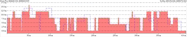
DHM
Quality Control in Elevation Modelling: Ensuring Accuracy
Now that we have unraveled the mystery behind DSM, DTM, and DHM elevation maps, it is important to talk about how the accuracy of these models is ensured. After all, in the world of telecommunications, every meter counts and signal quality is essential.
This is where QC (Quality Control) comes into play, a fundamental process to ensure that elevation maps are reliable and accurate.
Root Mean Square Error (RMSE)
RMSE is a key metric for assessing the accuracy of elevation models. In colloquial terms, RMSE tells us how close the values in the elevation model are to reality. It is like calculating how accurate an archer is at shooting arrows at a target.
The lower the RMSE value, the more accurate the model. Telecommunications experts understand the importance of low RMSE. It is crucial for accurate antenna placement. This ensures optimal connectivity.
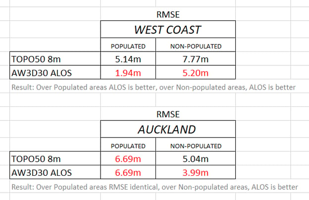
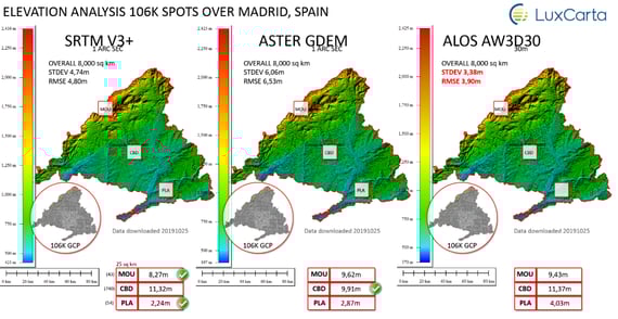
RMSE COMPARING TWO ELEVATION SOURCES IN DIFFERENT TYPES OF AREAS (POPULATED OR UNPOPULATED)
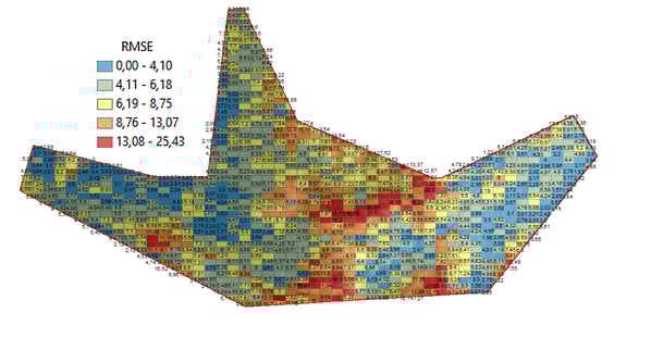
RMSE COMPARING TWO ELEVATION SOURCES OF 1 ARCSEC ELEVATIONS (APPROX 30m)
Ground Control Points (GCP)
Ground Control Points (GCP) are like navigational guide stars in the world of elevation modelling. They are reference points on the earth’s surface with known, precise geographic coordinates. Imagine you are building a jigsaw puzzle, and you need a few key pieces to make sure everything fits together perfectly. GCPs are those key pieces. Telecommunications specialists utilize GCPs. They verify and calibrate elevation models with them. This ensures each puzzle piece is correctly placed.
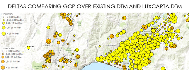
USING GCP TO CALCULATE DEVIATIONS TO GROUND TRUTH REFERENCE
Cross Validation
To further ensure the accuracy of elevation models, cross-validation is used.
This involves dividing the dataset into two parts. One part is used to construct the model. The other verifies its accuracy. It is like having a friend check your answers in a questionnaire. If both parts of the dataset match, you know you have a reliable model.
Elevation QC use case in Telecommunications
Finally, let us look at a case study that consists of comparing a DHM (which comes from geoprocessing a DSM and DTM and comparing it with an alternative source we have found on the web called Global Canopy Height.
1. We extract the DSM from LIDAR and then extract the DTM from the same area.
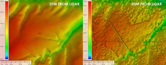
EXTRACTION OF DSM AND DTM FROM A LIDAR SOURCE
2. Calculate the DHM using a difference map.
We vectorize the source tree heights over the same area. This allows us to take references for homogeneous zones. In this case, I have chosen the centroid of the polygon as the exact location of the height. DHM vs. GLOBAL CANOPY HEIGHT.
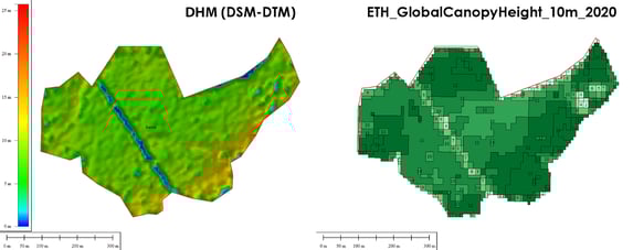
DHM vs. GLOBAL CANOPY HEIGHT
3. Finally, we compare one by one each of the height points of the Global Canopy Height and extract the deviation data.
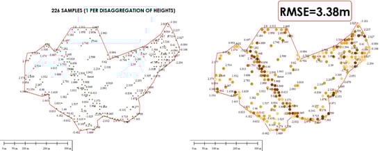
DHM vs GLOBAL CANOPY HEIGHT
Recall that we only want to know roughly if the Global Canopy Height source is good enough with respect to the original LIDAR. In this case, our conclusion is positive.
In the telecommunications business, where accuracy is paramount, quality control in DSM, DTM, and DHM elevation models is essential. RMSE, GCPs, and cross-validation are like the operators (real, live, breathing, physical people!) of quality that ensure that elevation maps are trustworthy. Thanks to these processes, we can be confident for example that antennas are placed in the right places and that signals are flowing smoothly. So, the next time you make a phone call or stream a video online, remember that behind the scenes, these quality controls are working hard to ensure you have the best possible communication experience.
THE IMPORTANCE OF QC IN TELECOMMUNICATIONS (and everywhere!)
Looking to boost the precision of your 5G network planning? Discover how 3D maps make the difference.
