Listen to audio version of this blog post:
When you are planning a GIS mapping project, ground resolution and scale are key considerations. Different resolutions are more or less appropriate for different scenarios. How do you choose the right resolution level for your project?
At a glance:
- Ground resolution is a key consideration when creating a GIS map
- Different kinds of project benefit from different levels of spatial resolution
- We define key terms for GIS maps
- Learn about the impact of resolution in GIS mapping
- Get tips and insights on which scale and image resolution you need
Imagine you are sitting in the window seat of an airplane as it makes its descent to the ground. To start with, you can only see the big features of the landscape – the gray outline of cities, patches of forest, and farmland. But as the plane gets closer to the ground, individual roads come into view, then buildings, and, finally, individual vehicles, trees, and even people.
Anyone who’s observed this increasing detail at the end of a flight will intuitively understand the importance of ground resolution in GIS mapping. High-ground resolution gives you lots of detail close-up, but you can’t see the bigger picture. Low ground resolution lets you observe a wider area, but you see less detail.
Now, if you’re creating maps for a project, it’s not always clear which scale you need, and how much detail is required. Is a low-resolution image at the landscape scale sufficient, or do you need high-resolution images showing individual trees and buildings?
To decide what ground resolution you need in your GIS maps, it’s first useful to understand some key terms. We’ll then provide tips for which scale you need for different kinds of projects.
Understanding ground resolution in GIS: key terms
Modern Geographic Information Systems (GIS) allow you to attach information to a map and identify trends, monitor change, and spot problems. If you want to create a GIS map, it’s important to understand key terms around scale and resolution.
- Ground resolution: In GIS, ground resolution (also known as spatial resolution) refers to the ground area represented in a single pixel on your computer screen. For example, if your GIS map has a 1 meter ground resolution, this means that each pixel would cover an area of 1 square meter.
- Scale: The scale of a map tells you how features depicted on it relate to the things they represent in the real world. A building on a map might be shown as 1 cm long, but in the real world, it might be 10m in length. The map’s scale (1:1000 in this case) helps you understand the distances shown on the map.
- Ground sampling distance: GSD refers to the distance between the centers of two consecutive pixels on the ground. A low GSD of, say, 10 cm, means each pixel represents 10 cm on the ground. A higher GSD of 100 cm means each pixel represents one meter on the ground.
- Ground sampling distance vs spatial resolution: In GIS, spatial resolution affects the level of detail in an image - a high spatial resolution means there is more detail visible, and will produce high-res maps. Spatial resolution refers to the amount of detail visible, whereas GSD is about the size of a pixel as measured on the ground.
Different kinds of sensors produce different ground sampling distance. The lowest GSD can be achieved using aerial imagery from a drone to capture extremely high image resolution (but with a more restricted field of view), an airplane mounted with LiDAR for medium GSD, or satellites that capture higher GSD (but also cover a large area).
So how is GSD calculated? The equation is as follows:
| Sensor Width x Flight Altitude | |
| GDS = | ---------------------------------------- |
| Focal length x Image width |
Factors to consider when choosing ground resolution for your maps
Different kinds of GIS projects will benefit from using imagery and maps of different scales and spatial resolutions. Here are some of the key factors to consider when deciding what level of resolution you need:
- Cost: Generally speaking, high-ground resolution and GSD costs more money to produce (and purchase) - the image sensors tend to be more expensive to purchase and operate. But lower-resolution images tend to be cheaper or even free.
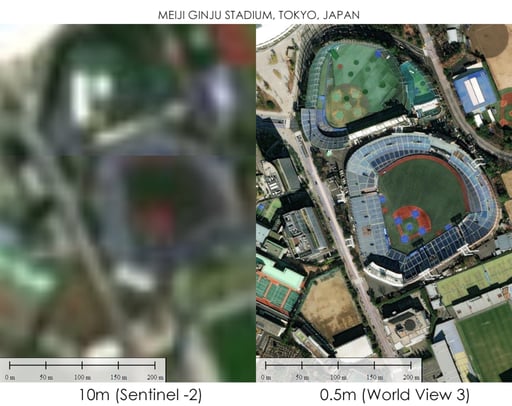
- Availability: Today, thousands of public and private satellites constantly capture images of Earth’s surface. These satellites are equipped with image sensors, each offering distinct capabilities. For instance, Sentinel satellites regularly acquire medium-resolution images (10-meter resolution). On the other hand, satellites like Pleiades from Airbus provide very high-resolution images (50 cm) but visit the same location less frequently and may not cover all regions worldwide.
- Storage and computing: As a rule of thumb, the higher the resolution of the image, the more storage and computing power are needed to process it.
- Area coverage: Do you want your map to show an entire country, an individual city, or just a single street? The area coverage you’re seeking will affect the kind of ground resolution needed.
Case study: Explore LuxCarta’s high-ground resolution San Diego 3D city model
Different resolutions for different purposes
When building a GIS map, you can choose between medium and high-resolution remote sensing satellite images. None of these options is inherently better than the other – your choice will depend on the needs of your project.
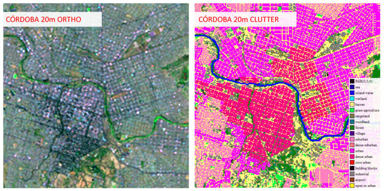
Use of medium ground resolution GIS maps (~ 10m)
Medium ground resolution GIS maps (~10 m) are valuable tools in the telecom industry and simulation & training sectors. Here are some examples of their use in these fields:
Telecom Industry:
- Network Planning: GIS maps of medium resolution assist telecom companies in network planning. They identify ideal spots for cell towers. This includes considering population density, terrain, and interference sources.
- Coverage Analysis: GIS maps enable telecom operators to visualize and analyze coverage gaps, helping them prioritize network expansion and upgrades.
- Line-of-Sight Analysis: Medium-resolution maps are useful for determining line-of-sight connections between cell towers, ensuring optimal network performance and connectivity, and helping planners take accurate measurements.
Simulation & Training:
- Emergency Response Training: Medium-resolution GIS maps can be incorporated into training simulations for emergency responders, helping them navigate and plan resource allocation during crisis scenarios.
- Military Training: By using up-to-date aerial imagery, GIS maps provide realistic environments for military training simulations, allowing personnel to practice navigation, terrain analysis, and tactical decision-making.
- Flight Simulations: Medium-resolution maps help create realistic flight simulators. Pilots can practice navigation, takeoffs, landings, and emergency procedures safely.
- Urban Planning Simulations: GIS maps are essential in urban planning training programs, enabling trainees to analyze land use patterns, population distribution, and infrastructure development in a simulated environment.
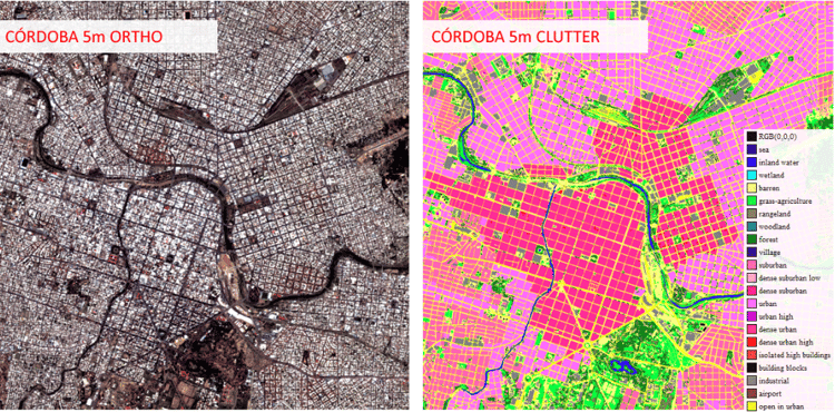
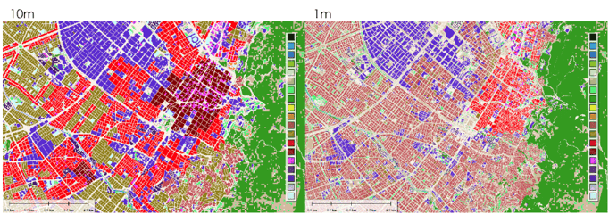
Use of high-ground resolution GIS maps (~ 1m)
High-resolution GIS maps with a 50 cm resolution offer even greater detail and accuracy, which can be advantageous in various industries. Here are some examples of high-resolution satellite imagery uses in the telecom industry and simulation & training sectors:
Telecom Industry:
- Micro Network Planning: High-resolution GIS maps enable RF planners to map out micro networks, such as small cells and distributed antenna systems with precision by identifying optimal locations based on building layouts, urban features, and population density.
- Precise Coverage Analysis: The increased detail in 50 cm resolution maps allows for more accurate measurements of coverage analysis, helping telecom operators to identify and address dead zones and weak signal areas.
- Infrastructure Management: High-resolution maps based on remote sensing can help telecom companies monitor and manage their infrastructure, including the precise placement of fiber optic cables and equipment maintenance.
- 3D Network Planning: Using high-resolution GIS maps, telecom operators can interact with detailed 3D models of urban environments, which can help optimize the network performance in complex cityscapes.
Simulation & Training:
- Detailed Emergency Response Training: High-resolution GIS maps enhance emergency response training. They accurately depict real-world environments. This allows responders to navigate better. It also improves resource allocation in training scenarios.
- Tactical Military Training: 50 cm resolution maps offer increased detail. This enhancement boosts the realism in military training simulations. Personnel can practice navigation with more accuracy. They also improve at reconnaissance. Target identification becomes more precise.
- Advanced Flight Simulations: High-resolution maps enable the creation of realistic flight simulators. These allow pilots to practice navigation and terrain recognition. They can also perfect precise landings in a safe setting.
Suggested: How satellite images are used to create 3D models
LuxCarta provides maps at the ground resolution you need
Every GIS map is unique, and your needs will vary significantly depending on the purpose of your project. LuxCarta has experienced teams ready to supply maps for your GIS projects. We offer a wide range of scales and spatial resolutions, down to 50 cm. Our teams use satellite images from various remote sensing sources. These range from 10-meter resolution to 50-centimeter stereo images. We can customize your maps and their detail level to fit your specific needs.
Contact us today for support in creating maps for your project.

Frequently asked questions
We answer your questions about the impact of resolution in GIS mapping.
What is the ideal ground resolution for satellite imagery in GIS?
It completely depends on the purpose of your mapping project. For projects that need a very high level of detail (e.g. planning locations for 5G mmWave antennas), then you will benefit from maps with a high resolution level. But other projects (e.g. market research), can be completed with lower resolution maps.
What is the difference between spatial and ground resolution?
In GIS, spatial resolution refers to the amount of detail that pixels in an image show, whereas ground resolution refers to the ground area represented in a single pixel. A map with high spatial resolution will show more detail. Ground resolution tells you whether a single pixel represents 10cm², 1m², or even 1km².
How does ground resolution impact GIS accuracy?
Ground resolution can affect accuracy of the decisions you make based on a GIS map. The higher the ground resolution, the more information will be shown in each pixel on your screen. That means you will be able to make more informed decisions.
That being said, low ground resolution doesn’t necessarily mean a GIS map is inaccurate. It just means there is less ‘fine’ detail. For example, a map with low ground resolution might still accurately represent the course of a river - it just won’t let you see where the banks are so clearly.
Why is high-resolution imagery important in urban planning?
Maps with a high resolution level can be very valuable in some kinds of urban planning. For example, if you are measuring flood risk from a river, a high resolution map can help you accurately assess how far water could spread. Equally, if you’re assessing air pollution levels when planning the location of a school, a high resolution map can show potential barriers to the spread of particulate matter (e.g. trees). This can help inform decisions.