FTTH Rollout Planning with Building Footprints & GIS Data
Faster and More Reliable FTTH Rollout Planning with Advanced GIS Maps

Planning a Fiber-to-the-Home (FTTH) rollout becomes significantly more efficient when network designers rely on high-resolution 2D and 3D GIS data instead of field-heavy surveys and manual route sketches. Accurate digital maps make it possible to anticipate constraints, design routes remotely, and validate technical choices before any crew isdeployed.
By working from detailed geospatial layers, buildings, vegetation, land use, population,and terrain, planners reduce uncertainty, shorten planning cycles, and scale deployments beyond dense urban areas.
What is FTTH rollout planning?
FTTH rollout planning is the process of designing fiber routes, estimating materials, assessing terrain constraints, and validating deployment strategies before construction begins.
Only 22
Countries (out of 195) that have achieved FTTH penetration rates of 50% or above*
1 %
Increase in GDP for every 10% increase in household broadband access**
< 40 %
Of households in most developing countries have any kind of broadband contract**
* Source: FTTH Council
** Source: World Broadband Association
Why FTTH planning still struggles to scale?
Many ISPs and telecom operators still rely on site visits, vehicle mapping, or fragmented basemaps to understand terrain and obstacles, especially in rural or complex environments. These approaches work locally but become costly and slow when rollouts expand across regions or countries.
As FTTH moves beyond urban “low-hanging fruit,” scalable and consistent planningbecomes a critical advantage.
How advanced GIS maps improve FTTH rollout efficiency?
High-quality GIS layers provide planners with a clear, pre-extracted view of theenvironment. Instead of discovering constraints on the ground, teams can design andvalidate routes directly in their GIS or network planning software.
In practice, this enables:
• Faster route design (underground, aerial, or façade)
• Early obstacle avoidance (buildings, vegetation, water bodies)
• More accurate material estimation and cost control
• Better prioritization of rollout zones based on building and population distribution
The GIS layers that matter most for FTTH
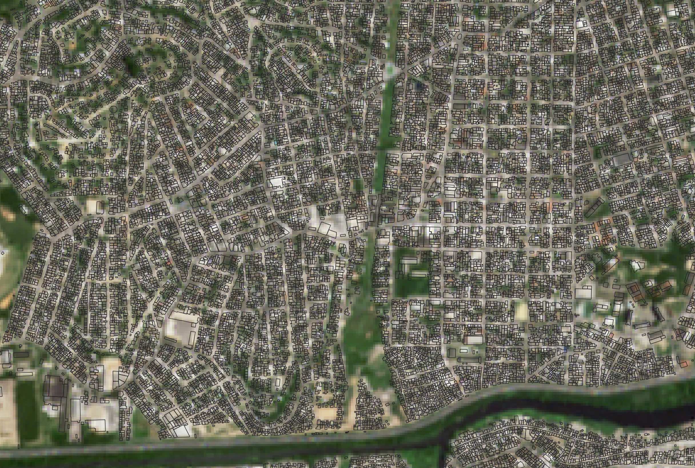
Building footprints (2D/3D) help locate premises, design efficient drops, and avoid routing conflicts while supporting cabinet and splitter placement.
Vegetation data highlights tree lines and canopy density, supporting safer aerial routesand lower-risk underground trenching.
Land use / land cover provides context on roads, farmland, forests, rivers, andbridges, reducing redesign caused by unexpected access or environmental constraints.
Population density maps support rollout prioritization and investment decisions,especially where official data is limited or outdated.
Elevation and topography reveal slope, drainage, and flood-prone areas, helpingreduce construction risk and long-term maintenance issues.
LuxCarta’s solution for FTTH planning
LuxCarta delivers AI-enhanced 2D and 3D geospatial layers derived from satellite imagery with resolutions up to 30 cm. Through the BrightEarth platform, planner saccess consistent, GIS-ready datasets including buildings, vegetation, land use,population density (PopMaps), and elevation.
The same production framework supports projects from a single municipality to nationwide FTTH rollouts.

Typical FTTH use cases
Rural expansion
Identify villages and least-risk corridors before field mobilization
Urban densification
Optimize routing around buildings and right-of-way constraints
Permit acceleration
Support EIA documentation with clear environmental context
Reliability planning
Avoid flood-prone or high-risk terrain early in the design phase
Get Your FTTH Project Started with LuxCarta
We have 30+ years’ experience working with telcos worldwide to plan the rollout of new technology. Our groundbreaking, AI-powered mapping solutions are ideally suited to the needs of companies delivering fiber to the home (FTTH) in countries that lack accurate or up-to-date cadastral information.
We help you rapidly identify buildings across entire regions, so you can plan your FTTH rollout most effectively. Contact us today to learn how we can help you plan your FTTH service.
Summary
Scalable FTTH deployments require scalable geospatial intelligence. High-resolution, AI-enhanced GIS layers enable operators to design faster, reduce risk, and accelerate permitting with confidence.