HDTM: Hydro-Enforced Digital Terrain Models for Accurate Water Flow Modeling
What is a Hydro-Enforced Digital Terrain Model (HDTM)?
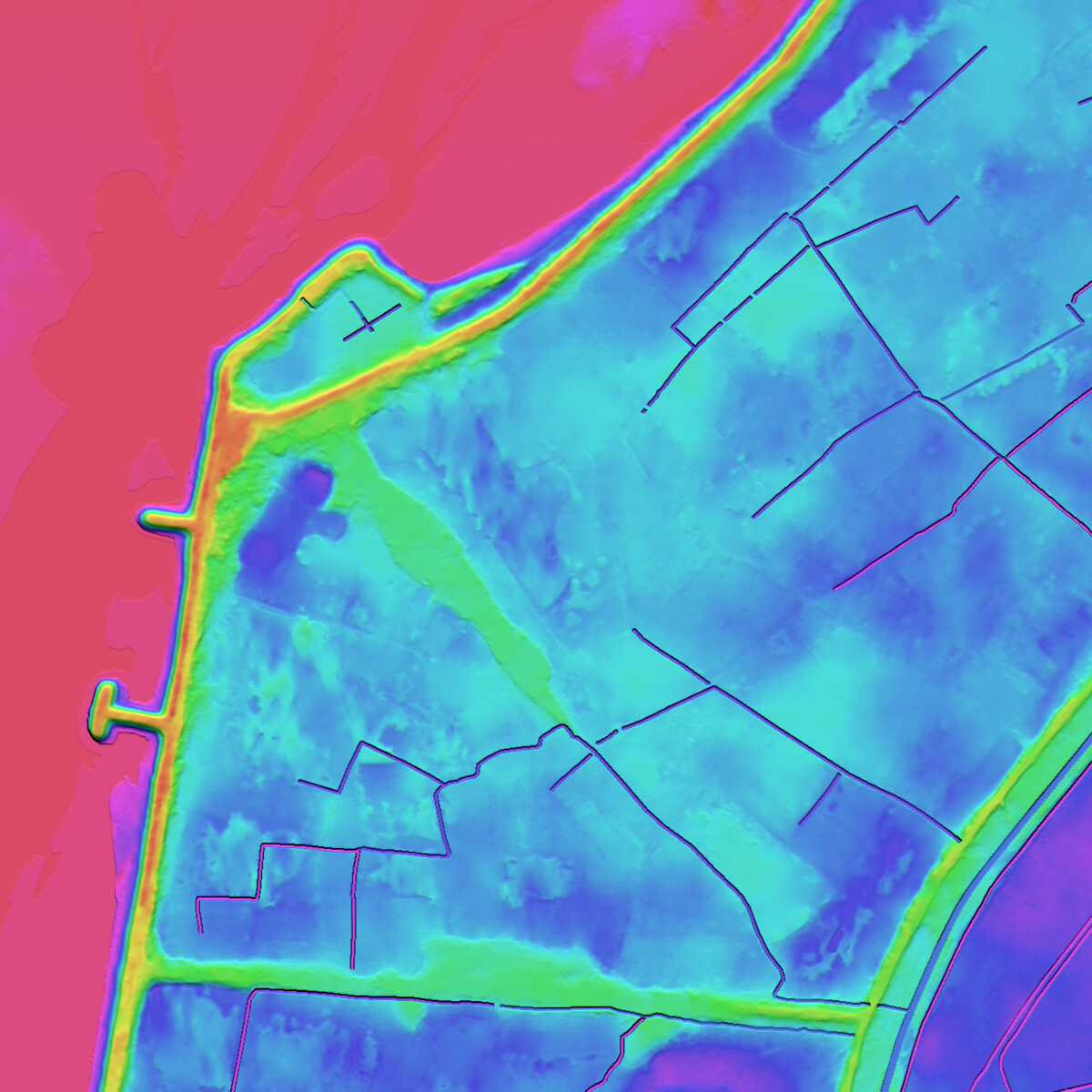
A Hydro-Enforced Digital Terrain Model (HDTM) is a bare-earth elevation model that has been hydrologically corrected to ensure realistic, continuous, and consistent water flow across the terrain.
Unlike a standard Digital Terrain Model (DTM), HDTM removes artificial obstacles, flattens water bodies to a single elevation, and adjusts river networks to reflect true downstream drainage behavior.
HDTM is specifically designed for flood risk assessment, watershed analysis, hydraulic simulations, and infrastructure planning.
Why LuxCarta’s HDTM is Different
LuxCarta’s HDTM is derived from high-resolution satellite imagery (30–50 cm or 1 m) and refined using advanced AI-enhanced workflows.
The result is a hydrologically reliable terrain model optimized for:
- Floodplain mapping
- Hydraulic and watershed modeling
- Urban drainage design
- Infrastructure and telecom planning
- Environmental and climate risk assessment
Why HDTM Matters Compared to a Standard DTM
A standard Digital Terrain Model (DTM) represents bare-earth elevation but does not enforce hydrological behavior. While suitable for general topographic analysis, it may contain subtle elevation artefacts that disrupt realistic water flow.
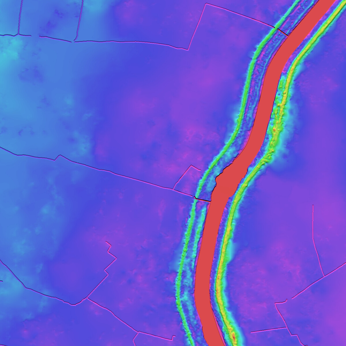
By contrast, a Hydro-Enforced Digital Terrain Model (HDTM) goes a step further. It corrects artificial barriers, levels water bodies, and ensures continuous downstream flow across rivers and drainage networks.
The result is a terrain model that is not only topographically accurate, but also hydrologically consistent, a critical distinction for flood risk analysis, hydraulic simulation, and infrastructure planning.
Key Advantages of HDTM

Hydrologically Correct Elevation Data
Ensures accurate representation of rivers, streams, lakes, and drainage flow paths.
Removal of Artificial Obstacles
Corrects embankments, bridges, culverts, and man-made artefacts that disrupt natural water flow.

Simulation-Ready Terrain
Delivers clean elevation datasets optimized for hydraulic modeling software and GIS platforms.

Improved Modeling Accuracy
Aligns terrain data with real-world hydrological behavior, reducing flood simulation errors.
How HDTM is Created (Step-by-Step Process)
LuxCarta’s HDTM is produced through a structured 5-step workflow:
- DSM generation from high-resolution satellite imagery
- Removal of above-ground features (buildings, vegetation)
- Hydrologic enforcement of rivers and water bodies
- Quality control and validation
- Delivery in GIS-ready formats
Start with High-Resolution DSM
The process begins with LuxCarta’s Digital Surface Model (DSM), generated from 30–50 cm or 1 m tri-stereo satellite imagery and supported by RGB/NIR orthoimagery. These high-resolution inputs provide detailed elevation data that captures both natural terrain and above-ground features such as buildings and vegetation.
Simulation-Ready
Each HDTM dataset undergoes automated hydrological consistency checks followed by expert validation. This dual workflow ensures elevation continuity, correct downstream flow, and suitability for flood risk modeling.
Hydrologic Enforcement
The next stage ensures that water flow is realistic and consistent across the terrain:
-
Water bodies (such as lakes, large rivers, and the sea) are flattened to a single elevation.
-
Major rivers and streams are adjusted so that water flows smoothly downstream without interruptions.
- Bridges and culverts are modified so water can flow underneath rather than being blocked.
- Areas with many buildings or dense trees, where automatic processing may miss water features
- Stream channels that are hard to see due to vegetation
- Agricultural areas with irrigation channels
Quality-Controlled
Deliverables
- HDTM (hydrologically corrected DTM, GeoTIFF)
- Optional: DSM, Orthoimagery, Contours (SHP), Breaklines (SHP)
Applications of LuxCarta’s HDTM
LuxCarta’s Hydro-Enforced Digital Terrain Models support critical engineering and environmental workflows where hydrological accuracy is essential.
Floodplain Mapping & Disaster Planning
HDTM provides hydrologically consistent elevation data to improve flood zone delineation, emergency scenario modeling, and disaster risk mitigation planning.
Urban Drainage Design
Accurate terrain slopes and corrected water flow paths help engineers design stormwater systems and urban drainage infrastructure more reliably.
Watershed & Hydraulic Modeling
HDTM ensures continuous downstream flow, enabling precise watershed delineation and hydraulic simulation across complex terrain.
Environmental monitoring & climate risk assessment
Hydrologically enforced terrain models support climate adaptation studies, flood forecasting, and long-term environmental impact analysis.
Frequently Asked Questions
Find answers to common questions about LuxCarta’s HDTM and their applications in flood risk analysis, telecom planning, and geospatial modeling.
What is an HDTM and how is it different from a standard DTM?
A Hydro-Enforced Digital Terrain Model (HDTM) is a bare-earth elevation model that has been hydrologically corrected to ensure realistic and continuous water flow across the terrain.
Unlike a standard Digital Terrain Model (DTM), HDTM removes artificial obstacles such as bridges and culverts, flattens water bodies to a consistent elevation, and adjusts river networks to reflect true downstream drainage behavior.
This makes HDTM particularly reliable for flood risk modeling, watershed analysis, and hydraulic simulation.
How accurate is LuxCarta’s HDTM?
LuxCarta’s HDTM is derived from high-resolution DSM imagery (30–50 cm or 1 m), combined with RGB or NIR orthorectified data.
The model achieves sub-meter vertical accuracy (typically <1 m RMSE), while hydrological corrections ensure realistic downstream water flow representation.
Accuracy may vary depending on terrain complexity, source resolution, and project specifications.
How long does delivery take?
Typical delivery timelines are approximately 4 weeks after order confirmation, depending on the size of the Area of Interest (AOI) and optional layers requested (such as contours or breaklines).
Larger regional or national-scale projects may require extended production timelines.