DSM : High-Resolution Digital Surface Models for Accurate 3D Mapping
Get an Accurate View of Terrain, Buildings & Vegetation with DSM
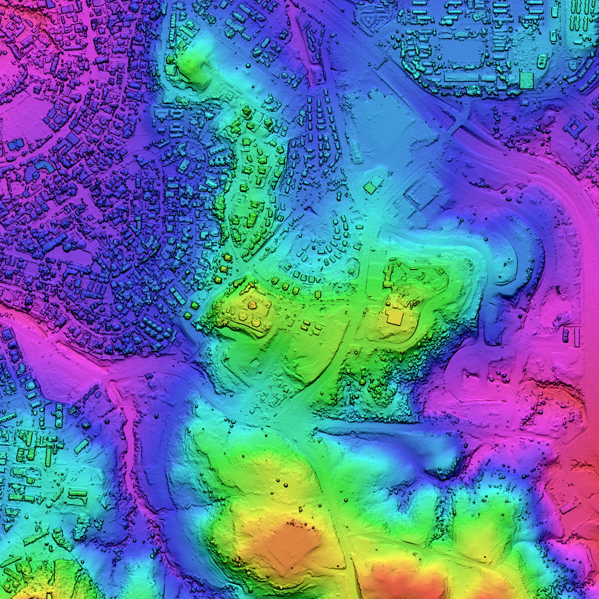
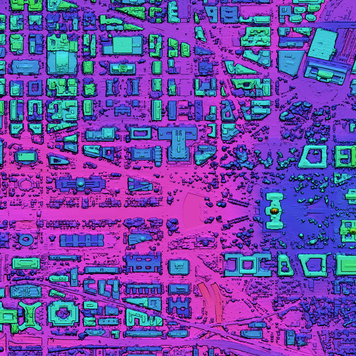
LuxCarta’s DSM captures the elevation of everything visible from above - A Digital Surface Model (DSM) is a high-resolution, three-dimensional representation of the Earth's surface that captures all visible features, including natural terrain, buildings, vegetation, and other structures. A DSM provides exceptional detail and accuracy for analyzing complex environments. Through sophisticated photogrammetric processing, precise elevation values are calculated for each pixel, resulting in a continuous surface model that accurately represents the "as-is" topography with all its above-ground features.
Derived from tri-stereo/stereo satellite imagery, this product supports detailed urban modeling, environmental assessments, disaster simulations, and infrastructure planning.

Comprehensive Surface Representation
Captures terrain, buildings, and vegetation for detailled 3D models.

Reduced Occlusions for Accuracy
Tri-stereo imagery improves completeness by up to 40%.

Adjusted Water Surfaces
Large lakes, rivers, and oceans are flattened to remove wave patterns.

Seamless GIS Integration
Delivered in GeoTIFF format, ready for all GIS, CAD, and modeling platforms.
How We Build DSM: From Imagery to Actionable Models
LuxCarta’s DSM is generated through advanced automated workflows using tri-stereo satellite imagery. These processes ensure maximum accuracy and usability for telecom and geospatial applications.
High-Resolution Data Acquisition
DSM production starts with tri-stereo satellite imagery.
The three viewing angles capture multiple perspectives of the same area, drastically reducing blind spots compared to standard stereo. This method ensures that rooftops, tree canopies, and ground features are clearly visible, even in dense urban environments or shaded areas.
Advanced Photogrammetry & AI Processing
Through automated stereo photogrammetry enhanced by AI algorithms, surface elevations are extracted with exceptional precision.
This process reconstructs the landscape in 3D, capturing terrain, buildings, vegetation, and infrastructure. AI-driven quality checks reduce noise and fill gaps, delivering a model that is both complete and reliable across large areas.
Accuracy Enhancement with Control Points
To refine positional accuracy, DSM integrates Ground Control Points (GCPs) during processing.
-
With GCPs: accuracy can reach <0.1 m RMSE.
-
Without GCPs: accuracy remains around <1 m RMSE, thanks to sensor calibration and robust photogrammetric workflows.
This flexibility ensures DSM can be adapted to regions with different levels of ground reference availability.
Water Surface Treatment & Refinement
Natural water bodies are specifically corrected to enhance surface realism:
-
Seas and large lakes are flattened to remove wave artifacts.
-
Rivers are hydrologically adjusted to follow natural flow.
-
Missing or inconsistent elevation values are interpolated for a smooth, continuous dataset.
These refinements make DSM particularly useful for urban planning, telecom line-of-sight analysis, and simulation environments.
Ready-to-Use Deliverables
The final DSM is delivered in GeoTIFF (32-bit float) format, using UTM/WGS84 (horizontal) and EGM2008 (vertical) standards.
It integrates seamlessly with GIS, CAD, RF planning, and 3D simulation tools, enabling engineers, planners, and telecom operators to start working immediately without additional processing.
Applications
Urban expansion, disaster resilience, environmental simulation
Risk analysis and visual impact assessments
3D mapping for infrastructure planning and terrain understanding
Integrate your Population Density Map With All Planning Technology
List of Integrations: Information on software, tools, and services that the product integrates with, enhancing its utility and flexibility.
Integration Details: Brief explanations of how each integration adds value to the user experience.
Testimonials and Case Studies
Learn how global telecommunications firms are benefiting from LuxCarta’s unique population density map solution.
“We needed a way to show our senior leadership team that marketing was producing results, and that’s hard when your metrics are scattered. This dashboard saved the day.”
“We needed a way to show our senior leadership team that marketing was producing results, and that’s hard when your metrics are scattered. This dashboard saved the day.”
Frequently Asked Questions
Find answers to frequently asked questions about LuxCarta’s DSM and its applications in telecom, urban planning, and 3D modeling.
What is a Digital Surface Model (DSM)?
A Digital Surface Model (DSM) is a type of elevation model that represents the height of everything visible on the Earth’s surface. Unlike a Digital Elevation Model (DEM), which only shows the bare terrain, a DSM includes buildings, vegetation, and infrastructure on top of the ground. This makes DSM data especially valuable for telecom planning, where signal propagation can be blocked by obstacles; for urban modeling, where city planners need to understand the built environment; and for 3D simulations, where realistic landscapes are required. By using tri-stereo satellite imagery, LuxCarta’s DSM provides a highly detailed and accurate representation of surface elevations, enabling precise analyses and decision-making.
How accurate is LuxCarta’s DSM?
LuxCarta’s DSM offers industry-leading accuracy thanks to the combination of tri-stereo imagery and Ground Control Points (GCPs). When GCPs are included in the processing, the DSM achieves better than 0.1 m RMSE (Root Mean Square Error), which is highly precise even for telecom-grade applications like 5G line-of-sight planning. In areas where GCPs are unavailable, the DSM still delivers accuracies of ~<1 m RMSE, thanks to rigorous photogrammetric workflows and satellite sensor calibration. This level of accuracy ensures that engineers, telecom operators, and urban planners can rely on DSM data for tasks ranging from antenna placement optimization to smart city infrastructure development.
What are the typical use cases for DSM?
A Digital Surface Model is used in a wide variety of industries where understanding both the natural and built environment is critical. In telecommunications, DSM supports 5G rollout, microwave link planning, and coverage optimization by accurately modeling obstacles that affect radio signals. In urban planning and smart city projects, DSM is used to simulate cityscapes, evaluate zoning, and model future expansions. DSM is also vital for environmental analysis, such as monitoring vegetation growth, simulating flood risks, or assessing climate resilience. Finally, in simulation and training environments, DSM creates highly realistic 3D terrains that can be used for defense, aviation, or emergency response training.
How long does it take to deliver a DSM?
The delivery time for a Digital Surface Model (DSM) is usually around 4 weeks after order confirmation, depending on the size of the Area of Interest (AOI). This period covers the full workflow: acquisition of tri-stereo imagery, processing with AI-powered photogrammetry, integration of Ground Control Points (GCPs) when available, and final quality control. The DSM is then delivered in GeoTIFF (32-bit float) format, ready to use in GIS, CAD, RF planning, and 3D simulation tools.
Ready to integrate LuxCarta’s DxM into your projects?
Get in touch with our team to explore how DSM, DTM, or HDTM can support your next simulation, infrastructure plan, or risk assessment.